Wednesday, 5 June 2024

Day 18: Poolside or Holy Guacamole It's Hot!

Twentynine Palms, (near Joshua Tree National Park, California

Distance for the day: 134.9 km

Cumulative distance: 3923.4 km

Top speed: 117 kph

Moving average: 72 kph

Temperature: 25.8 - 40.8

I would call this a "short day". And I think it may well be a record for hot weather riding for us. It is hot. 

We were up pretty early and on the road before 9:00 am, in an effort to beat some of the heat. We knew we had only a short ride today but we still wanted to get away in decent time. Going forward, for the next week and change, I expect that will be our M.O. We both wore shorts under our riding gear and light weight tops. At times, I would stand on the pegs of the bike to allow the wind to flow through my mesh riding gear. The only bad part was that we had two sections of road where work was being done and we had to wait in line on the highway; the second time, for about 15 minutes. Fortunately, that was still early in the morning and it was only in the high 20s. Crossing the desert was brutally hot. We saw only one other motorcycle today and it wasn't someone touring, just some guy going from A to B in a t-shirt and jeans. 

We had our first and only stop in Yucca Valley and we spotted a Starbucks where each of us was envisioning an iced coffee of some sort. I had to turn around on a busy highway to get to it and when we dismounted and walked up to the door, there was a sign indicating "drive through or phone orders only". Well, it was too hot to drive through or to sit outside, so we went next door to some kind of juice bar, which was probably not a bad idea as we could get hydrated really well. However, we still haven't had a coffee today and we are both missing it. We spent an hour in there, not worrying about the time because the ride from Yucca Valley to Twentynine Palms is only 30 km, so I used the time to decide where we were going to stay. There are lots of options for the area and this, ironically, is not the prime tourist season since June marks the beginning of the summer hot season. We opt for a place called 29 Palms Inn, in part because the pictures show a nice pool set up, which is where we are currently parked. Drinking beer. The top of my beer can is hot. 

They were gracious enough to allow us to check in just past noon even though I knew they had other fish to fry at that time of day.  It is a small boutique motel and while it looks a little like there are no other guests, there has been  steady flow of customers to the bar and restaurant this afternoon.  It is a nice treat after camping.

We are outside Joshua National Park. We want to go into the park but not too keen on riding around in the heat so what we have decided is to relax this afternoon, get up early tomorrow and ride into the park, then come back to the hotel for breakfast. If we really like what we see, we will return to the park tomorrow evening.


 In the bar where we are sttaying.


Tuesday, 4 June 2024

Day 17: It's My way or the Byway

Big Bear Lake, San Bernardino Forest, California

Distance for the day: 289.1 km

Cumulative distance: 3788.5 km

Top speed: 120 kph

Moving average: 61 kph

Temperature: 26.4 - 36.2 (we actually saw it over 37 but that was inside the town of Palmdale, so I don't count that because the bike is moving slowly between traffic lights.

Elevation: 2114 metres

First off, my most humble apologies for failing to properly turn on the tracking device. I thought I had done it and discovered when we got to a campground that it had not been on all day. If you are a total map nerd (like me) and want to know where we rode, here is our route for today: from McGill Campground back down Mount Pinos Rd, then followed Cuddy Valley Rd,  Frazier Ltn Park Rd, then right onto Ralph's Ranch Rd, which crosses under the I5 snf yutnd into Gormon Post Rd, we connect with CA 138 for a few kilometres, then deviate right onto Old Ridge Route N2 which was a very twisty up and down that waws so old, grass was growing in the cracks in the pavement. The N2 then tuns into Elizabeth Lake Rd and just as we were at the outskirts of Palmdale, had an outstanding lunch at Jack's Place. We zigzagged through Palmdale and got back on CA 138, past Silverwood Lake, where 138 turns into "Rim of the Lake Scenic Byway" and turns south past Crestline, which, if you have followed this far, you can see is a total squiggle zone, through Rimforest, Running Springs and then the south side of Big Bear Lake, where we are unsuccessful in reaching Pineknot Campground due to the steep gravel road approach so swing around to the north side of the lake and Serrano Campground. That took me about 15 minutes to figure out.

I was awake early (5:00 am) and outside to check the stars and they were brilliant. And, to my amazement, it was fairly mild, which surprised me given how cold it was when I went to bed. The result of which I finally did go back to sleep and slept in till 8:00 a.m. I'M RETIRED AND I DON'T CARE. 

But after re-organizing my bags of clothing so that I could replace a torn ziploc styled bag for my rain suit, it was 10:30 by the time we hit the road. Not overly happy with the campground, there was no water. Plus, when we asked the camp host about bear safety and food storage, he said "just throw it in your car" then told several bear encounter stories that had occurred in the campground. We explained that we didn't have a car and he seemed totally lost and didn't know what to say so we asked if we could store our food and other related in his c-can and he thought that would be acceptable. 

It didn't take long to warm up. In fact, it was warm when we started and in short order we were talking about peeling off layers. We toughed it out till lunch time but afterwards, I lost all I could, which included both shirts that I was wearing. I kept my wits and my pants about me but I was happy I had my "track" pants on and not my jeans.  Tomorrow, I'll start out in shorts, depending what time we get going.

Where we camped.


Our camping guest.

As we rode over the Rim highway and through Rimforest, we had quite a view over the neighbouring valley where we had a bird's eye view of San Bernardino, which is a outside suburb of Los Angeles. Other than stopping at the airport to change planes, this is the closest to LA I have come.


This is part of the aquaduct system
that feeds LA with water.


This was the road that had
grass growing in the cracks.


This is one of the reasons we don't like to ride Interstate highways.

When we arrived at Big Bear Lake, we looked for a particular campground that was poorly marked and hard to access on a big street-based motorcycle so we ditched that plan and rode around to the other side of the lake were there are located a couple of other state campgrounds. The public campgrounds are generally a little cheaper and aren't so crowded. When we arrived at our campground of  (second) choice, we discovered that they had ONE site left, out of a total of 132. Plus, it was a DOUBLE campsite, so cost $79. I suggested she just sell the other side but that didn't go over so well. It is still cheaper than a fleabag motel.


This is an abandoned hotel in Fawnskin. The area is very wealthy but the wealth is primarily on the other side of Big Bear Lake. I guess this is "Lower Bear Lake"

This is a solar observatory at Big Bear. It is not primarily a tourist offering but a research facility. However, for lucky people, therer are occasional openings for tours for non-reearch people.


Monday, 3 June 2024

Day 16: Everything Old Is New Again, including this post title

Day 16: McGill Campground, Chumash Wilderness, California

Distance for the day: 321.4 km

Cumulative distance: 3499.4 km

Top speed: 116 kph

Moving average: 73 kph

Temperature: 18.8 - 33.0 

Oilers: Stanley Cup contenders

Elevation: 2308 metres, versus 1, which we have been living for the past two weeks.

I'm pretty sure I have used that post title on a past blog and that would be because I have been in a similar situation. 

Every morning on this trip, it seems, we think we are going to get away and then we don't. Or we DO, then we (the Royal We) realize that something is wrong, like what's up with the GPS saying go that way or it's not saying anything at all.
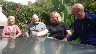
Kathy, Warren, Nan and me sitting
around the post breakfast table.

Enjoying their beautiful
garden with citrus fruits...

...and bird of paradise.

We left our gracious hosts' place just past 10:30. It was a relaxed morning; we were fed and served espressos so that we could be sufficiently wired for the road. We didn't get two kilometres before I realized that we were going the wrong way, whichever way that was. Last night, Warren had pulled out some big paper maps so that we could have an all encompassing, bird's eye view of California, Arizona, new Mexico and Colorado to make some good and interesting route decisions. Warren had proposed we take Hwy 58 east

This is the house in Toronto, now occupied by our
friends Daryl and Wendy and once owned by Warren't
grandmother,
who is sitting on the porch.


from Santa Margarita to Frazier Park, which is just before we would hit Interstate 5 which goes south to L.A. I entered that into my Google Maps and it actually gave me a different proposed route which would take us over Hwy 166. Then Warren said "but wait, there's more!" He said that would also be a very good way, a little shorter and maybe even a little better than Hwy 58. So there we are, heading north towards Santa Margarita and I realized I hadn't programmed Hwy 166 into the GPS and couldn't actually remember which highway was the one to take us south, then east to Frazier Park. I said to Nan that we had to stop to sort this out. Two kilometres from our starting point. 

Since I didn't remember which was the southern route, we elected to just keep keep heading north and watch for the signs for Santa Margarita  and surely it couldn't be a big deal to just follow the road until we saw Hwy 58. So we are riding up Hwy 101, backtracking the way we had come down, soon saw the exit sign for Santa Margarita and Hwy 58 and took that exit. Easy. As. Pie.

Until we blew by the turnoff for Hwy 58 and continued heading north. Shortly, I realized

Oops. Not where we are supposed to be.


that we were riding parallel to Hwy 101 and I just knew that wasn't right so once again, we stopped to get our bearings. Then we turned around, rode back 7 km and found the turnoff. BTW, the sign for Hwy 58 was virtually enshrouded in tree branches and leave, at least, this time.  

First sign we see: "Route not recommended for trucks", which we thought was a good sign, both figuratively and literally.  So, as had been foreseen, it was a good, twisty road through lush, pretty countryside, some small farms and a few wineries. 

Once through the hills and out onto the plains, we quickly realized we were in ranch

Where we are supposed to be.


Oh oh. Someone didn't make the turn.


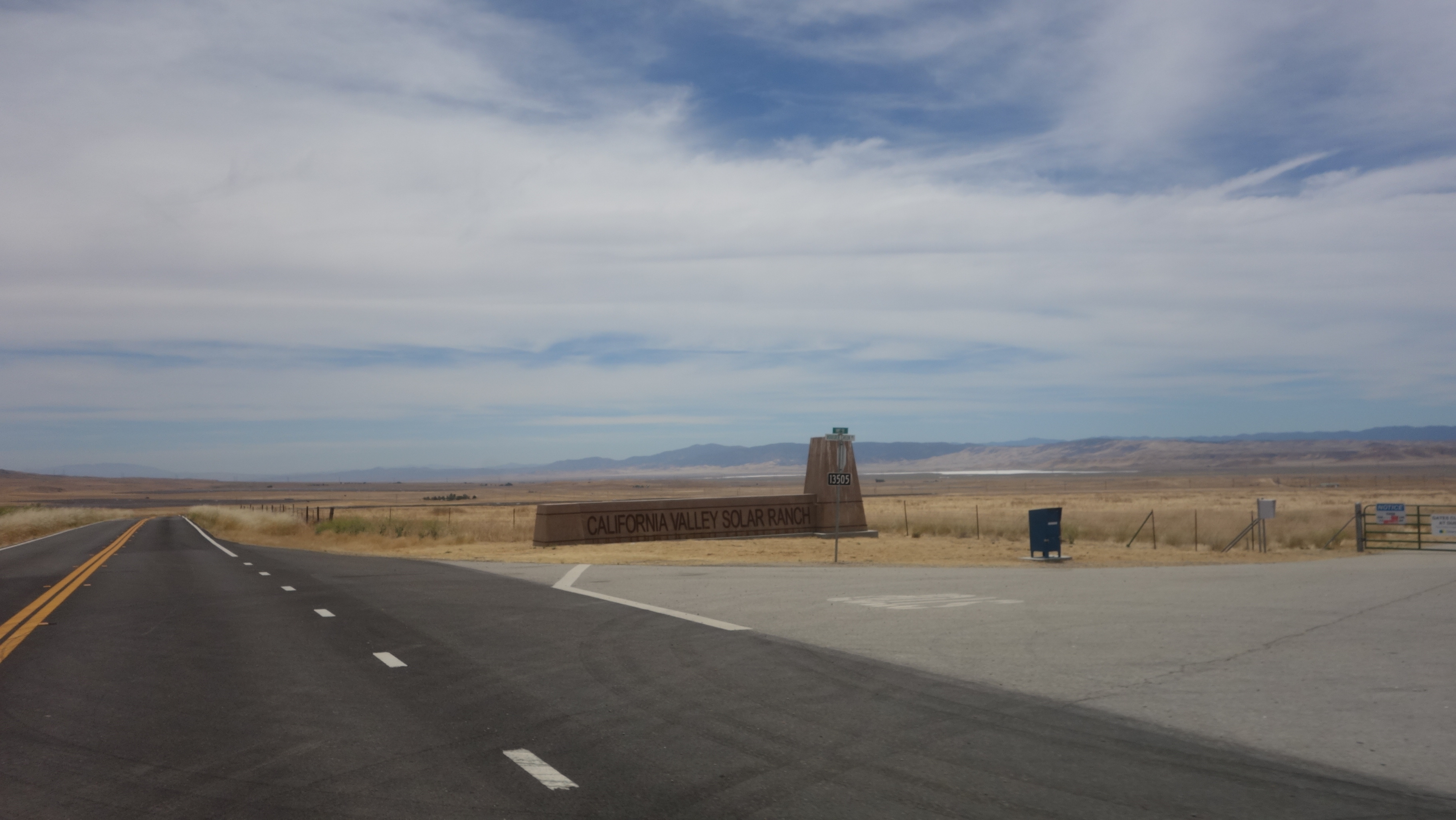
country. SOLAR ranch! We thought that was hilarious that they are upping their cache by calling their solar farm a solar ranch! The California Solar Ranch. I bet there is a lot of wrangling going on there, much more so than at the Topaz Solar Farm, which we had passed by a few minutes earlier. Both had what appeared to be hundreds of acres of solar panels.

We were our riding in desolate country at this point. There were wide, open plains
The solar ranch. You can see
the panels in the background.

followed by a smattering of oil pump jacks, then a congestion of pump jacks where hundreds were squeezed into a few acres. There must have been a rich deposit below. It looked out of a science fiction movie of some future desolate, far off planet being exploited for its resources. Especially as we entered the related community of Daft, sorry, Taft, many of the businesses seemed to be shuttered. However, that did improve as we got closer to the centre of the town. 

After a generous break at the Daft Starbucks, by which I mean generous to Starbucks, with new coordinates programmed into the GPS (HA!) we headed out again. Editor's Note: I do not generally used voice commands from the GPS when I am riding with Nan because the GPS interupts us, so I rely on the screen to take my cues when to turn. We are riding down what we think is Hwy 58, having continued on the route we had used into Taft. Unbeknowst to me, we were now on Highway 166. Sound familiar? Then I see a sign that says how far it is to Hwy 101 but I think it must be referencing some alternate route. But get this: we are heading WEST. I don't pick up on this fact, though until, after about 20 minutes, the GPS is signaling to me to turn around. This I find very frustrating when I have been watching the route on the GPS and it is suddenly talling me I should be going the opposite direction. We pull over so that I can sort this out.  

Turns out we have followed the highway, which has curved around and started back towards the coast. I don't even realize we have changed direction. But I check the GPS compass and we are clearly heading west.  I reset the GPS target once again only this time entering the coordinates of a campground that might make a worthy target for the night. and we have to retrace 24 km, which you can clearly see on the tracking map. I am embarrassed and humiliated. I've made Nan suffer these extra 50 km on her tender tootsie. I wasn't even certain how it happened though my theory was that the GPS had been pointing to the turn and I just didn't notice and blew past it. The GPS continued to show me to keep going because it thought I had to get all the way to New Cuyama for a safe place to turn around. Sheesh.


We get off 166 and onto the Hudson Ranch Road. I find this name interesting because the only ranch or really, any kind of rural dwelling didnt even appear to be occupied. Maybe it was a ghost house. But the road goes through spectacular hilly country and while Nan is snapping away, I am keeping my eyes to the road but eventually I say I have to stop and take a look because I had never seen anything like it.

Continuing on, we are getting some good elevation and the surroundings are more dense forest. Also, there is a slight uptick in traffic, which is comforting because initially, we thought we were on the loneliest road in California.  We actually came to Pine Mountain Club, a name I had seen on the map and assumed it was some sort of special camp for kids or someother. It was actually quite an elaborate little town with services and businesses - in the middle of nowhere. 

We made the turnoff to the campground which turned out to be about 8 kilometres off the highway on a steep uphill incline on, I am happy to say, paved road. 

It is 9:00 10 degrees and windy so that's it.


Sunday, 2 June 2024

FOAF

Day 15: Pismo Beach, California

Distance for the day: 323.6 km

Cumulative distance: 3178.0 km

Top speed: 131 kph

Moving average: 83 kph

Temperature: 16.2 - 31.8 

We don't normally ride with an agenda but today we have one: get to Pismo Beach, just south of San Luis Obispo on the coast at a reasonable hour and spend as little time on the freeway as practical. We have new friends here and they have invited us to stay over, Warren and Kathy. Warren is almost a Canadian. His grandmother emigrated to Toronto in 1922 at the age of 4 and lived in a house which is now currently occupied by good friends of ours Wendy and Daryl, (such good friends in fact, that they are pulling up stakes and moving to the Okanagan). Well, a couple of years ago Warren was in Toronto and being a lover of architecture, wanted to see his grandmother's old house, make sure it was still standing and for nostaliga's sake. This was at best, a small challenge for Warren as he knew the location well because as a kid growning up, he would come from Philadelphia to visit his grandmother every summer. And Warren stood outside photographing the house. This went on for a few minutes and lest Wendy or a neighbour be suspicious of this activity, Warren thought he had better knock on the door and present his credentials: a picture of the house from when his grandmother lived there lest their be any worry that his intentions were nefarious.

Wendy answered the door and after a brief discussion, invited Warren to have a look around the house to see what Wendy and Daryl had done with it and give Warren his nostalgia fix. How can you not love that? OK, well, friends of ours who are/were police officers, but who else?

Warren and Wendy became friends through this action and last September when I was doing my solo warm up motorcycle trip in anticiapation of THIS trip, Wendy told Warren that her friend (me) might be traveling down close to where he lives! Warren looks at the blog and reaches out to me through the "comments" section and tells me I would be welcome to stay with he and Kathy if I was in the area.  Also, he gave me some road guidance on Hwy 1, which at that time had been closed for nine months due to the rock and mud slides in January of '23 taking out the coastal highway. Alas, as it turned out, I did not venture so far south, turning east at Manchester, much further north than here.

This makes Warren (and his beloved Kathy) in the vernacular of urban legends, a FOAF, or Friend Of A Friend.

Warren is an avid motorcyclist with his steed being a pristine BMW 1200 adventure tourer. This turns out to be very helpful to us because he gives us some route suggestions to get from Santa Cruz to Pismo Beach and miss out on some of the freeway. And the recommendation is phenomenol! We have to retrace yesterday's steps to Carmel -By-The-Sea (I wonder if people who live there get tired of typing that out?) and then turn south on Carmel Valley Road, which is a narrow, twisty ride along a creek through wine and ranch country. How narrow and twisty you ask? Well, this is a perfect opportunity to remind you about the Inverse Road Line Rule: the fun riding a road is inversely proportional to the number of lines painted on a road. IE: fewer lines being more fun! And while the road starts out with about a dozen lines, in short order there are fewer and fewer until eventually there are NONE. Well how much fun is THAT!?

We ride down Carmel Valley Road until we get almost to Greenfield. The road is enclosed by trees, surrounded by hilly ranch country and in places, wineries and further along, MASSIVE wineries with what looks like thousand of acres of vines.  That may well be the case but of course, it is not possible from the road to determine who acutually owns which vine.  The vines all look healthy here. 

Eventually, we get back on to Highway 101 for a couple of hours of slab riding because it is just not practical to take the back roads all the way to Pisbo Beach. And we stop at Wildhorse to get a small lunch. 

We arrive before 4:00 p.m. so we have a little while for a visit and to settle in then go for a fabulous dinner - far and away the best meal we have eaten since I cooked for her at home last.


Day 42: Home Sweet Home

West Kelowna, BC Distance for the day: 282.7.5 km Cumulative distance: 9,665.7 km Top speed: 119 kph Moving average: 75 kph Temperature:  21...